"ATLANTIDE BRITANIQUE" DÉCOUVERTE AU FOND DE LA MER DU NORD
UN VASTE MONDE SOUS-MARIN ENGLOUTI PAR LES EAUX EN 6500 av. JC
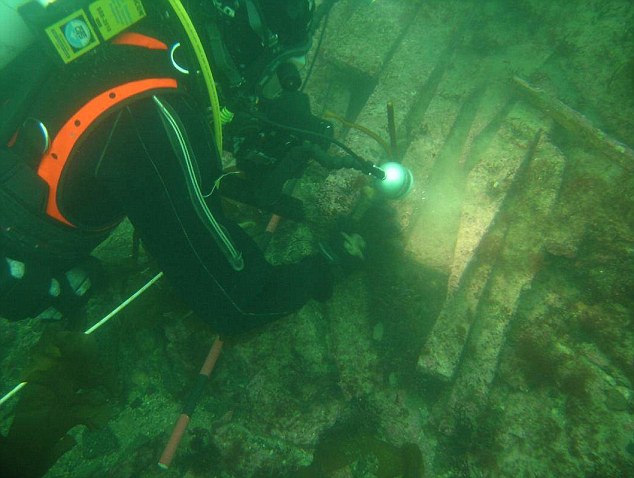
- Des plongeurs ont trouvé des vestiges d'anciennes terres englouties par les flots il y a 8500 ans.
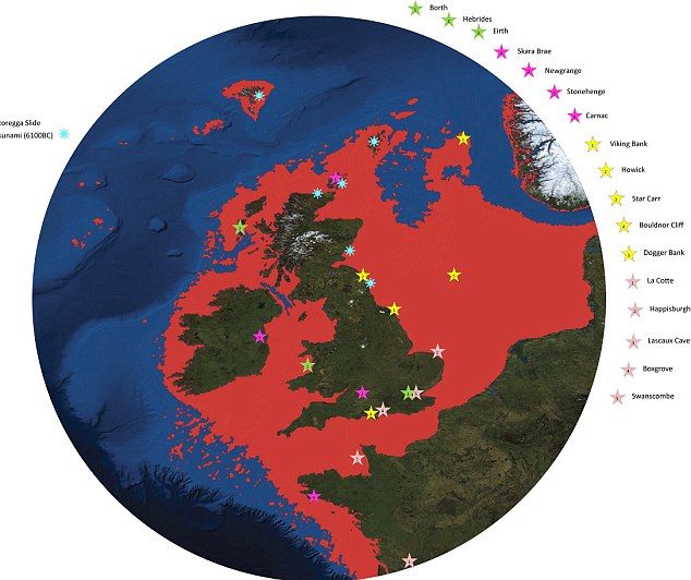
- Doggerland s'étendait autrefois de l'Écosse au Danemark.
- Des cours d'eau repérés sous l'eau par des analyses sismiques.
- La Grande-Bretagne n'était pas une île - et la région sous la mer du Nord a été parcourue par des mammouths et autres animaux géants.
- Décrit comme le « cœur réel » de l'Europe.
- Avait une population de plusieurs dizaines de milliers de personnes - mais fut détruit par les
hausses du niveau de la mer.
"'Britain's Atlantis" - un monde caché sous-marin englouti par la mer du Nord - a été découvert par des plongeurs qui travaillent avec des équipes scientifiques de l'Université de St Andrews.
Doggerland, une vaste zone de terre ferme qui s'étend de l'Écosse au Danemark, fut lentement submergé par l'eau entre 18.000 et 5.500 avant J.C.
Des plongeurs de compagnies pétrolières ont trouvé des vestiges d'un "monde noyé" d'une population de plusieurs dizaines de milliers de personnes qui pourrait bien avoir été le « cœur réel » de l'Europe.
Une équipe de climatologues, archéologues et les géophysiciens ont cartographié la zone à l'aide de nouvelles données provenant des compagnies pétrolières - et ont révélé l'ampleur du "pays perdu" parcouru jadis par des mammouths.
La recherche suggère que les populations de ces terres submergées aurait pu être de dizaines de milliers de personnes, vivant dans une zone qui s'étendait de l'Écosse du Nord jusqu'au Danemark et en bas de la Manche jusqu'aux îles Anglo-Normandes.
La région était autrefois le «
cœur réel » de l'Europe et a été frappé par «
un tsunami dévastateur », affirment les chercheurs.
La vague faisait partie d'un processus plus vaste qui a submergé la zone de basse altitude au cours de milliers d'années.
«
The name was coined for Dogger Bank, but it applies to any of several periods when the North Sea was land », says Richard Bates of the University of St Andrews. «
Around 20,000 years ago, there was a "maximum" - although part of this area would have been covered with ice. When the ice melted, more land was revealed - but the sea level also rose.
Through a lot of new data from oil and gas companies, we’re able to give form to the landscape - and make sense of the mammoths found out there, and the reindeer. We’re able to understand the types of people who were there.
People seem to think rising sea levels are a new thing - but it’s a cycle of Earht history that has happened many many times. »
Organised by Dr Richard Bates of the Department of Earth Sciences at St Andrews, the Drowned Landscapes exhibit reveals the human story behind Doggerland, a now submerged area of the North Sea that was once larger than many modern European countries.
«
We have speculated for years on the lost land's existence from bones dredged by fishermen all over the North Sea, but it's only since working with oil companies in the last few years that we have been able to re-create what this lost land looked like.
When the data was first being processed, I thought it unlikely to give us any useful information, however as more area was covered it revealed a vast and complex landscape.
We have now been able to model its flora and fauna, build up a picture of the ancient people that lived there and begin to understand some of the dramatic events that subsequently changed the land, including the sea rising and a devastating tsunami. »
The research project is a collaboration between St Andrews and the Universities of Aberdeen, Birmingham, Dundee and Wales Trinity St David.
Rediscovering the land through pioneering scientific research, the research reveals a story of a dramatic past that featured massive climate change. The public exhibit brings back to life the Mesolithic populations of Doggerland through artefacts discovered deep within the sea bed.
The research, a result of a painstaking 15 years of fieldwork around the murky waters of the UK, is one of the highlights of the London event.
The interactive display examines the lost landscape of Doggerland and includes artefacts from various times represented by the exhibit - from pieces of flint used by humans as tools to the animals that also inhabited these lands.
Using a combination of geophysical modelling of data obtained from oil and gas companies and direct evidence from material recovered from the seafloor, the research team was able to build up a reconstruction of the lost land.
The findings suggest a picture of a land with hills and valleys, large swamps and lakes with major rivers dissecting a convoluted coastline.
Les scanner sismiques révèlent une rivière submergée
As the sea rose the hills would have become an isolated archipelago of low islands. By examining the fossil record - such as pollen grains, microfauna and macrofauna - the researchers can tell what kind of vegetation grew in Doggerland and what animals roamed there.
Using this information, they were able to build up a model of the 'carrying capacity' of the land and work out roughly how many humans could have lived there.
The research team is currently investigating more evidence of human behaviour, including possible human burial sites, intriguing standing stones and a mass mammoth grave.
Dr Bates added: «
We haven't found an "x marks the spot" or "Joe created this", but we have found many artefacts and submerged features that are very difficult to explain by natural causes, such as mounds surrounded by ditches and fossilised tree stumps on the seafloor.
There is actually very little evidence left because much of it has eroded underwater; it's like trying to find just part of a needle within a haystack. What we have found though is a remarkable amount of evidence and we are now able to pinpoint the best places to find preserved signs of life. »
For further information on the exhibit, visit: http://sse.royalsociety.org/2012/exhibits/drowned-landscapes/
Drowned Landscapes is on display at The Royal Society Summer Science Exhibition 2012 from July 3-8 at the Royal Society in London.
source:

http://www.dailymail.co.uk/sciencetech/article-2167731/Britains-Atlantis-North-sea--huge-undersea-kingdom-swamped-tsunami-5-500-years-ago.html#ixzz1zfy7GTpk